• You need to be a registered member of Barbel Fishing World to post on these forums. Some of the forums are hidden from non-members. Please refer to the instructions on the ‘Register’ page for details of how to join the new incarnation of BFW...

Feature finding advice.

Julian Griffiths

Senior Member
Hi guys.
Very rarely do you find me casting far on rivers, but I'm going to be fishing wider parts of the river where I feel the fish may well be.
Yes. Some of my near bank features can never be ignored, but I also want to target & locate mid river features.

Other than casting a lead around to 'feel about' and count the drop of the lead, I want to be s bit more methodical and a bit more accurate.
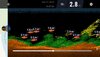
What options do you guys adopt on new stretches, and do these smart sonars play a part in your river fishing. And are they worth the investment?(I'm not talking small intimate streams here)

I'm not going in either!😉

Cheers all!
 
I know afew guys that cast out and trott down these deeper devices and within minutes they’ve completely mapped out a section of river.
For me personally it’s a little step too far into the world of cheating but the readings obtained and transferred into a phone screen are something quite spectacular.
I personally like a lead about but if you haven’t done it before it can be quite tricky to get something useful from it.
I like to start upstream close in and work my way across to the far bank casting and feathering a lead. Draw a mental picture in your head of where the depth tapers both up and down then repeat the process moving down stream slightly.
If it’s a completely new bit of water to me where I actually don’t know the depth I will use a float and stop and keep playing with the stop till I get an exact depth. Once you’ve found the deepest point it’s easy from there to map out shelves and tapers but it’s an art to be able to draw out exactly what’s infront if you through feathering lead.
I can almost do pretty much what a deeper can do it just takes me a lot longer. I’m ok with that.
 
Jump in a small inflatable boat with a sonar and go up and down. Find some interesting spots (or not!) then lead about to see what the bottom is like.

Expensive and time consuming yes, but it’s also fun and accurate. Appreciate not all stretches allow boats so I’d be using a deeper pro thing in that case.
 
Use a Deeper Pro sonar. It maps the river or lake bed for you and displays features such as weeds and sunken trees as well as depth and surface water temperature. The Lakebook program isn't perfect, but with a bit of nous and ingenuity you can accurately map out a swim in minutes and from that get a plan of which direction to cast to and how far.

A cheaper option is the Lucky range of fish finders. They display, but do not record, data so you allow the sonar to trot down the swim at different distance from the bank and observe the screen. You end up with a mental map, not a digital one like the Deeper Pro'.

I have a telescopic rod set up with a clip that I can attach the sonar to and can map out a likely swim in a fraction of the time it takes to do a float and plummet operation.
 
I've a hand held screen with a depth transducer that is attached to a wire trace and cast with a lure rod (to avoid loss if grabbed by a pike). It's light so it's not being cast that far using a multiplier. It gets me about half way on the TT. I cast out, and either let it go downstream with the current, or not give line, and let it swing around in an arc to the nearside bank. The advantage is the rapid accuracy of assessing the depth and contours without the swim disturbance of using a lead and a float.
 
I know afew guys that cast out and trott down these deeper devices and within minutes they’ve completely mapped out a section of river.
For me personally it’s a little step too far into the world of cheating but the readings obtained and transferred into a phone screen are something quite spectacular.
I personally like a lead about but if you haven’t done it before it can be quite tricky to get something useful from it.
I like to start upstream close in and work my way across to the far bank casting and feathering a lead. Draw a mental picture in your head of where the depth tapers both up and down then repeat the process moving down stream slightly.
If it’s a completely new bit of water to me where I actually don’t know the depth I will use a float and stop and keep playing with the stop till I get an exact depth. Once you’ve found the deepest point it’s easy from there to map out shelves and tapers but it’s an art to be able to draw out exactly what’s infront if you through feathering lead.
I can almost do pretty much what a deeper can do it just takes me a lot longer. I’m ok with that.
Nice insight to what you do. For me it's not about fish location, I prefer to fish the features and build a swim from there or prebait if it's a low stock area.😊
 
Use a Deeper Pro sonar. It maps the river or lake bed for you and displays features such as weeds and sunken trees as well as depth and surface water temperature. The Lakebook program isn't perfect, but with a bit of nous and ingenuity you can accurately map out a swim in minutes and from that get a plan of which direction to cast to and how far.

A cheaper option is the Lucky range of fish finders. They display, but do not record, data so you allow the sonar to trot down the swim at different distance from the bank and observe the screen. You end up with a mental map, not a digital one like the Deeper Pro'.

I have a telescopic rod set up with a clip that I can attach the sonar to and can map out a likely swim in a fraction of the time it takes to do a float and plummet operation.
Like this idea. Cheers.
 
The fish finder is probably the most misunderstood aspect of using these devices. The way they work is to send pulses out several times a second and on all but the most sophisticated units it can lead to the same one or two fish being show several times as though a shoal is there. Also, typically they have three sizes for fish; large, medium and small. Imagine deciding on the parameters between bleak and wels catfish. And the units do not differentiate between species. You have to work that bit out for yourself using experience and water craft.

The fish finder can be useful in certain situations. But it isn't the silver bullet that many people think that it is.
 
The nice thing about the Deeper is it’s speed, it is in reality no different to a marker float. It tells you depth and bottom texture, I’m not convinced on it’s ability to see fish. Obviously this is recorded automatically. So yeah, nothing ground breaking just a quicker version of the old technology.

Because it floats your less likely to snag it up than a lead, which is handy but it’s not cheap so you could buy plenty of floats and leads in comparison.
It does have its limitations though, the map doesn’t quite read like you’d expect, the birds eye view shows depth to the nearest 1m from memory, so this could miss a gully etc that’s important but less than this. For mapping lakes I think it’s probably handy, finding holes or shelves. You can also pop it on a boat and use it like a traditional sonar.

For me, the rivers I fish, they’re not big enough to utilise it... I can see most of this information with my eyes. If your working your margin, then it’s 100xs easier to just clip on a big lead and bounce it about...

I’ve considered selling mine tbh as it’s of little use but it was given to me.

Here’s some examples of what you get back. I suspect the “fish” are actually weed.
 

Attachments

  • 5580D7A1-5EB5-4495-A8DB-155F161ED85C.jpeg
    5580D7A1-5EB5-4495-A8DB-155F161ED85C.jpeg
    92 KB · Views: 270
  • EA54B3DB-6A24-4F87-BF4B-3A4F86E41AE7.png
    EA54B3DB-6A24-4F87-BF4B-3A4F86E41AE7.png
    118.9 KB · Views: 279
Last edited:
I think the "fish finding" aspect of sonars may be a boon for, say, freshwater bass anglers fishing from highly mobile light craft. But for UK anglers, especially those fishing rivers, I don't believe it's much of a 'bonus feature'. There may be someone on here that knows otherwise but, I've never heard of any river angler using a sonar to find (a) fish, cast to those (that) fish, and catch those (that) fish. Fish move, maybe more especially in rivers, whilst features (generally) don't. But for finding large bream shoals ...yes, maybe. Plot their patrols ....Mmmmm, could be.
For forming a contour map of a deep river or lake (>1m) then sonars can be immensely time saving, and the Deeper range saves having to make copious notes/draw maps etc that may be required using a 'Lucky' on a large expanse of water (I used one of the latter many years ago to map out a 100 acre reservoir which had depths to over 25m. The pen-work involved turned out to be more arduous than writing a dissertation/thesis 🤪 )
But for feature finding I'm no so sure. You soon realise that it's one thing getting data (easy) and another interpreting that data (not so easy). I've had many conversations with the Deeper guys, who are brilliantly upfront and honest about the limitations of (especially) their software. They accept that improvement is still necessary in regards to the sensitivity of their hardware, and the interpretation of data by their software. They will freely admit that it's still 'work in progress', especially when it comes to finding small (<0.5m) features in moving water.
You can have all the data you like but what matters is how accurately you interpret that data. Things are not always what they appears to be, and good old watercraft will beat any sonar device 'hands-down' IMO. That said, on large apparently feature-less expanses of water, sonars do have a place IMO (with apologies to Neil ...sorry mate, my methods are not always pure, simple, and low-tech. 😞😳)
 
Last edited:
The Lucky that I use (occasionally) just confirms what you can generally see by reading the water...inside and outside of bends etc. It merely speeds up what plumbing with a lead and float does without the swim disturbance. I am just after swim contours (deeper channels and where they start to shallow up generally). The cheap sonars are just providing the most basic of information.
 
Julian

I’ve got a Lucky that I’m not likely to use anytime soon that I can lend you if you want to have a go to see if you’ll get some benefit without forking out for one.

I‘ve only used it on still waters, it’s pretty accurate.
 
I think the "fish finding" aspect of sonars may be a boon for, say, freshwater bass anglers fishing from highly mobile light craft. But for UK anglers, especially those fishing rivers, I don't believe it's much of a 'bonus feature'. There may be someone on here that knows otherwise but, I've never heard of any river angler using a sonar to find (a) fish, cast to those (that) fish, and catch those (that) fish. Fish move, maybe more especially in rivers, whilst features (generally) don't. But for finding large bream shoals ...yes, maybe. Plot their patrols ....Mmmmm, could be.
For forming a contour map of a deep river or lake (>1m) then sonars can be immensely time saving, and the Deeper range saves having to make copious notes/draw maps etc that may be required using a 'Lucky' on a large expanse of water (I used one of the latter many years ago to map out a 100 acre reservoir which had depths to over 25m. The pen-work involved turned out to be more arduous than writing a dissertation/thesis 🤪 )
But for feature finding I'm no so sure. You soon realise that it's one thing getting data (easy) and another interpreting that data (not so easy). I've had many conversations with the Deeper guys, who are brilliantly upfront and honest about the limitations of (especially) their software. They accept that improvement is still necessary in regards to the sensitivity of their hardware, and the interpretation of data by their software. They will freely admit that it's still 'work in progress', especially when it comes to finding small (<0.5m) features in moving water.
You can have all the data you like but what matters is how accurately you interpret that data. Things are not always what they appears to be, and good old watercraft will beat any sonar device 'hands-down' IMO. That said, on large apparently feature-less expanses of water, sonars do have a place IMO (with apologies to Neil ...sorry mate, my methods are not always pure, simple, and low-tech. 😞😳)

I think Deeper have a more accurate and, of course, more expensive version now

My basic lucky finder has been very useful on gravel pits, especially on one where there are lots of bars and depths can go to 30ft, but I’ve only ever used it in a couple of swims at a time when I’ve fished them on the same or subsequent sessions.
Totally agree Dave, a Deeper or a Lucky would be ace on a gravel pit I reckon. And yes, I've heard that the new version of Deeper ("Chirp") is maybe 4 times more sensitive than the Pro+ (but I can't see me buying one). They're good close season toys anyway ;)
 
Nice insight to what you do. For me it's not about fish location, I prefer to fish the features and build a swim from there or prebait if it's a low stock area.😊
Absolutely.
It’s certainly not about spotting fish.
I think the deepers are great things I really do but Mapping a swim with a lead is quite a rewarding task but it just takes Skill and patience. You’ll Still find different types of beds, different depths, shelves, snags and one thing a deeper can’t tell you but a lead can is the power of the flow in the under Current. Just varying the weight itself can tell you a lot about a river when certain parts of the swim dislodge it and others don’t.
It’s not always what you assume from looking at the surface pattern either.
 
I think the "fish finding" aspect of sonars may be a boon for, say, freshwater bass anglers fishing from highly mobile light craft. But for UK anglers, especially those fishing rivers, I don't believe it's much of a 'bonus feature'. There may be someone on here that knows otherwise but, I've never heard of any river angler using a sonar to find (a) fish, cast to those (that) fish, and catch those (that) fish. Fish move, maybe more especially in rivers, whilst features (generally) don't. But for finding large bream shoals ...yes, maybe. Plot their patrols ....Mmmmm, could be.
For forming a contour map of a deep river or lake (>1m) then sonars can be immensely time saving, and the Deeper range saves having to make copious notes/draw maps etc that may be required using a 'Lucky' on a large expanse of water (I used one of the latter many years ago to map out a 100 acre reservoir which had depths to over 25m. The pen-work involved turned out to be more arduous than writing a dissertation/thesis 🤪 )
But for feature finding I'm no so sure. You soon realise that it's one thing getting data (easy) and another interpreting that data (not so easy). I've had many conversations with the Deeper guys, who are brilliantly upfront and honest about the limitations of (especially) their software. They accept that improvement is still necessary in regards to the sensitivity of their hardware, and the interpretation of data by their software. They will freely admit that it's still 'work in progress', especially when it comes to finding small (<0.5m) features in moving water.
You can have all the data you like but what matters is how accurately you interpret that data. Things are not always what they appears to be, and good old watercraft will beat any sonar device 'hands-down' IMO. That said, on large apparently feature-less expanses of water, sonars do have a place IMO (with apologies to Neil ...sorry mate, my methods are not always pure, simple, and low-tech. 😞😳)

There are problems with the Deeper. In fact they have over promised in their blurb and I am quite disappointed at the actual results. One of the problems is that the magnification of the swims isn't anywhwere near large enough and the more area you record the worse the problem becomes. Also, for some reason the mapped data does not match up with the map itself. Many of my swims are partly on dry land according the processed map.

That said, with a bit of ingenuity it is possible to clip up when the sonar is over a good mark and transfer that distance to the fishing rod or measure it out. Then using sight lines or compass points the mark can be cast to.

As regards casting to fish; I have seen a video of a French angling guide who found large catfish using the sonar. The arch was clearly visible and he could then instruct his clients to jig directly over the silure. He may have known where they were likely to be found, but the sonar put him right above the fish.
 
Also, for some reason the mapped data does not match up with the map itself. Many of my swims are partly on dry land according the processed map.

Yeah, that's a bugger innit 😂 😂 😂 , but that's more to do with geo-location/satellite positioning than the actual sonar widget itself. I don't know which of all the satellites it uses (same as Google Maps?) but all mobile phone geo-locators still takes several minutes to get your position down to the nearest couple of metres, and then it'll show you moving to and fro, when you're actually standing stock still. Then there's heavy cloud cover, and overhead tree branches etc. Deepers' positioning is not as stable/accurate as a decent SatNav IMO, and I reckon it'll take 5-10yrs to get a version that most river users would be 95% happy with.
BTW ...I know sod all about the intricacies of satellite navigation, but that may be obvious from above ("from above!!" 🤪)
 
I've used my deeper pro on the Yorkshire Ouse which is a deep river in places and can be very snaggy so leading around will mean losing the odd lead mapping out swims! Also casting a float and lead/plummet out will be tricky with the depth unless your using a slider!
So far over the past 2 seasons I've found some very interesting underwater features (If it is accurate) and in 1 of these swims a few of us have caught barbel where the swim shallows up!
 
Don’t believe in tech, Too much faffing about if i want to know what’s beneath the surface, I’ve always used a marker float. This also stems from when I was a kid fishing for tench, plumbing the depth with a plummet. These days I use a knobbly lead, and braided mainline . I don’t perform such tasks on the day I’m fishing, il visit the areas beforehand and build up the picture. Areas change with floods and stuff, features change. Granted I loose a few leads and floats, but some areas I fish have rubbish mobile signal.
 
Back
Top